
Philippines earthquake magnitude 7.8 Mindanao tsunami warning 2026 has triggered immediate coastal evacuations and emergency response across the southern Philippines and neighbouring Indonesia after a powerful tremor struck off the southern Philippine island of Mindanao on Monday, with the German Research Centre for Geosciences placing the quake at a depth of 10 kilometres and tsunami warnings being issued by the Philippines' Phivolcs agency, Indonesia's geophysics agency BKMG, and the U.S. Tsunami Warning System, advising people in coastal areas across multiple countries to move immediately to higher ground. Philippine President Ferdinand Marcos Jr said the national government was moving fast to coordinate disaster response and that Mindanao would not be left behind, activating the institutional emergency framework whose speed and coordination will determine whether the warnings translate into effective protection for the coastal communities in the quake's immediate impact zone. DZBB radio broadcasting from General Santos, approximately 15 kilometres from the epicentre, reported falling furniture, damage to televisions and other appliances, and aftershocks continuing to shake the area as residents left their homes seeking safety, while the General Santos disaster office confirmed it was assessing reports of damage and some injuries across the affected region.
The quake's specific physical characteristics, striking at a shallow depth of only 10 kilometres, amplified its surface shaking intensity significantly relative to what a deeper quake of the same magnitude would produce, because shallow earthquakes transmit more of their energy through the crust to the surface rather than dissipating it across a larger volume of rock before reaching populated areas. Phivolcs warned of damage and tsunami waves above one metre that could continue for several hours, a warning profile that requires sustained coastal evacuation rather than a brief shelter response, while Indonesia's BKMG reported initial wave measurements of 0.19 metres at early monitoring stations, a figure whose modest initial reading does not preclude larger waves arriving at subsequent monitoring points as the tsunami propagates across the ocean from the epicentre. The geophysical magnitude readings themselves showed some variation across agencies, with the German Research Centre reporting 7.8, the Philippine agency Phivolcs reporting 7.0, and Indonesia's BKMG reporting 7.7, a normal feature of rapid earthquake assessment that reflects the different methodologies and seismographic networks of the agencies reporting in the immediate aftermath of a major seismic event.
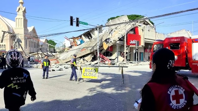
The human experience of the earthquake in Sarangani province captures both the physical intensity of a major quake and the institutional disruption that power and telecommunications failure creates in the immediate emergency response period, with Sarangani local disaster chief Rene Punzalan reporting that power and communications were both down across the province, school classes had been suspended, and a damage assessment was underway without yet confirming any collapsed buildings. Alabel town police chief Benjie Ancheta described the quake as the strongest he had experienced in his career, telling Reuters that the police building sustained cracks during the flag-raising ceremony when the quake struck, causing some people present to faint. Maasim town disaster chief Arlene Hollero reported that coastal village evacuations were underway, that no casualties had been reported yet in her jurisdiction, that water had receded shortly after the quake before the seas returned to normal, that a bridge had sustained cracks, and that a shrine with a large cross had collapsed, describing the situation as devastating in her phone call with Reuters.
Why the Philippines and Mindanao Are Among the World's Most Seismically Vulnerable Regions
The Philippines and Indonesia's shared position on the Pacific Ring of Fire, the seismically active belt stretching from South America across the Pacific to the Russian Far East, provides the geological context within which Monday's magnitude 7.8 earthquake represents not an extraordinary anomaly but the most severe expression of the continuous seismic activity that both countries experience at rates that place their populations among the most routinely earthquake-exposed in the world, with hundreds of quakes occurring annually across the archipelago and with the particular tectonic configuration of the Philippine plate boundaries creating the conditions for major events with relative regularity. The Ring of Fire's activity along the Philippine archipelago is generated by the convergence of multiple tectonic plates including the Pacific Plate, the Philippine Sea Plate, and the Eurasian Plate in a complex subduction and collision geometry that creates both the volcanic arc systems responsible for the Philippines' volcanoes and the subduction-generated seismicity responsible for the major earthquakes that repeatedly test the country's disaster response infrastructure. The shallow depth of Monday's quake, at only 10 kilometres compared to the 70 to 150 kilometres depth that would characterise a deeper subduction zone event of similar magnitude, reflects a fault rupture occurring at the very top of the crustal column in a way that maximises surface shaking and tsunami generation potential.
Mindanao specifically has experienced multiple significant earthquakes in recent decades, including the 1976 Moro Gulf earthquake and tsunami that killed more than 5,000 people, the 2019 Davao del Sur earthquakes that killed dozens and displaced thousands, and numerous other events that have shaped local disaster preparedness culture and tested the institutional response frameworks that Filipino emergency management agencies have been developing and refining through each successive major event. The institutional memory of past tsunami disasters in the region gives the coastal evacuation orders issued Monday a specific urgency that communities with previous experience of tsunami destruction will respond to more rapidly than those encountering the phenomenon for the first time, and the evacuation reports coming in from Maasim and other Sarangani towns suggest that the warnings are being acted upon rather than ignored. The Philippines' disaster risk reduction framework, developed over decades of experience with typhoons, earthquakes, volcanic eruptions, and tsunamis, provides the legal and operational basis for the rapid government response that Marcos has characterised as moving fast.
The General Santos City area, approximately 15 kilometres from the reported epicentre, is a major economic and commercial hub in southern Mindanao whose disruption carries consequences extending well beyond the immediate physical damage, because it serves as the regional centre for a large agricultural, fishing, and commercial catchment area whose economic activity depends on the infrastructure and connectivity that the quake has disrupted through power outages and telecommunications failures. The fallen furniture, damaged appliances, and aftershock activity that DZBB radio reported from General Santos describe the immediate household-level impact of a strong quake on a densely populated urban area, and the assessment of structural damage to more critical infrastructure including hospitals, emergency services facilities, and the road network will determine both the immediate disaster response capacity and the medium-term economic recovery trajectory of the region.
Indonesia's Exposure and the Cross-Border Tsunami Coordination Challenge
Indonesia's receipt of the tsunami warning alongside the Philippines reflects the specific geographic relationship between the epicentre off southern Mindanao and the Indonesian territory that lies within the tsunami propagation zone, with the waters between the southern Philippines and Indonesian Sulawesi providing the open ocean pathway through which any significant tsunami waves would travel toward Indonesian coastal communities. Indonesia's geophysics agency BKMG's initial wave height reading of 0.19 metres at monitoring stations represents the real-time data that emergency managers in both countries are watching to determine whether the physical tsunami manifestation is matching the theoretical propagation models that drove the initial warning, with the critical question being whether the early low readings reflect the full extent of the event or the leading edge of a wave train whose subsequent pulses may be larger. The witnesses in Indonesia's northern city of Manado who reported feeling the quake strongly confirm that the seismic energy was sufficient to be felt at significant distance from the epicentre, and the cross-border coordination challenge of managing tsunami warnings, evacuation orders, and damage assessment across two large archipelago nations with different emergency management systems and communication infrastructure requires the kind of regional cooperation protocols that the Pacific Tsunami Warning System was designed to facilitate.
Indonesia's no damage reports so far from its disaster mitigation agency spokesperson provides the early reassurance that the immediate Indonesian impact may be manageable, but the temporal gap between a major earthquake and the full propagation of its tsunami potential means that the no damage assessment of the immediate post-quake period does not represent a final all-clear for coastal communities in the warning zone. Tsunami wave travel times across the relevant water bodies can range from minutes to hours depending on the distance from the epicentre, meaning that communities receiving the warning have varying amounts of time to execute evacuations, and the sustained warning status that Phivolcs indicated could continue for several hours reflects the genuine physical uncertainty about when the hazard period ends rather than precautionary over-warning.
Evacuation Status, Damage Assessment, and What Emergency Responders Face
The convergence of power failure, telecommunications disruption, coastal evacuation, and ongoing aftershocks that Sarangani province is managing simultaneously in the immediate post-quake period represents the classic multi-system cascade that makes earthquake disaster response so operationally demanding, because the infrastructure disruptions that the quake itself causes are precisely the infrastructure that emergency responders need to coordinate effective response. Disaster chief Punzalan's assessment that no collapsed buildings had been reported yet in Sarangani is encouraging but represents an early status that will be updated as assessment teams reach areas where communications are still down, and the structural integrity picture will evolve over hours and days as inspectors access the full geography of the affected zone and as aftershocks continue to test any buildings that were weakened by the main event. Police chief Ancheta's description of the police building with cracks, people fainting during the flag-raising ceremony, and his characterisation of the quake as the strongest he had experienced provide the qualitative intensity assessment from someone with professional experience of the local seismic environment, and his account aligns with the severity that a shallow 7.8 magnitude quake in close proximity to a populated area would be expected to produce.
The water recession that Hollero described in Maasim town shortly after the quake, with seas subsequently returning to normal, is one of the most carefully watched indicators in the immediate post-quake monitoring period, because water drawback from coastal areas is a classic precursor to incoming tsunami waves rather than necessarily a sign of normalisation, and the transition from drawback to return-to-normal requires expert assessment rather than local visual observation to interpret correctly. The bridge cracks and shrine collapse that Hollero reported represent the kind of infrastructure and structural damage that accumulates rapidly in a major earthquake and that will require systematic assessment across the entire affected zone before the full damage picture can be established. Her use of the word devastating to describe what she is witnessing captures the psychological impact of the unfolding disaster on the local officials who are simultaneously managing emergency response and witnessing the destruction of the community infrastructure they normally administer.
The President's statement that the national government was moving fast and that Mindanao would not be left behind reflects both the operational reality of a government mobilising disaster response resources and the political communication imperative of demonstrating visible leadership in the immediate hours of a major disaster when public confidence in institutional response capacity is being formed. The National Disaster Risk Reduction and Management Council, which coordinates the Philippines' disaster response, will be activating its emergency protocols for logistics, search and rescue deployment, medical support, and international assistance coordination as the full scope of Monday's event becomes clearer through the damage assessment process that local officials have confirmed is underway. International offers of assistance from Japan, Australia, and other regional partners will be among the early diplomatic responses, with the Philippines' established disaster management relationships with regional partners providing the framework for coordinating whatever international support the scale of the event may require.